Note
Please report issues with the manual on the GitHub page.
1. Introduction
Surface Urban Energy and Water Balance Scheme (SUEWS) (Järvi et al. 2011 [J11], Ward et al. 2016 [W16]) is able to simulate the urban radiation, energy and water balances using only commonly measured meteorological variables and information about the surface cover. SUEWS utilizes an evaporation-interception approach (Grimmond et al. 1991 [G91]), similar to that used in forests, to model evaporation from urban surfaces.
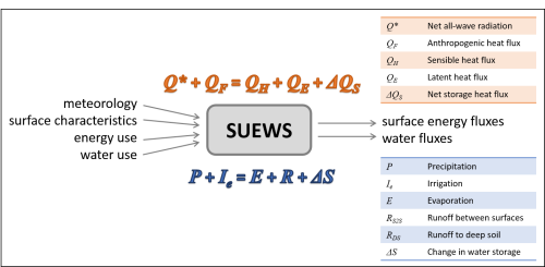
Fig. 1.1 Overview of SUEWS
The model uses seven surface types: paved, buildings, evergreen trees/shrubs, deciduous trees/shrubs, grass, bare soil and water. The surface state for each surface type at each time step is calculated from the running water balance of the canopy where the evaporation is calculated from the Penman-Monteith equation. The soil moisture below each surface type (excluding water) is taken into account.
Horizontal movement of water above and below ground level is allowed. The user can specify the model time-step, but 5 min is strongly recommended. The main output file is provided at a resolution of 60 min by default. The model provides the radiation and energy balance components, surface and soil wetness, surface and soil runoff and the drainage for each surface. Timestamps refer to the end of the averaging period.
Model applicability: SUEWS is a neighbourhood-scale or local-scale model.
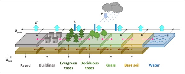
Fig. 1.2 The seven surface types considered in SUEWS