Note
Please report issues with the manual on the GitHub page.
15. Notation
- λF
Frontal area index
- ΔQS
Storage heat flux
- BLUEWS
Boundary Layer part of SUEWS
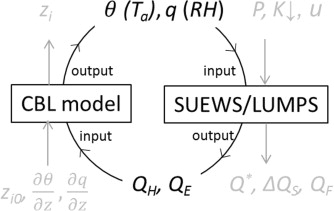
Fig. 15.1 Relation between BLUEWS and SUEWS
- CDD
Cooling degree days
- GDD
Growing degree days
- HDD
Heating degree days
- Bldgs
Building surface
- CBL
Convective boundary layer
- DEM
Digital Elevation Model
- DSM
Digital surface model
- DTM
Digital Terrain Model
- DecTr
Deciduous trees and shrubs
- EveTr
Evergreen trees and shrubs
- ESTM
Element Surface Temperature Method (Offerle et al.,2005 [OGF2005])
- Grass
Grass surface
- BSoil
Unmanaged land and/or bare soil
- Runoff
The water that drains freely off the impervious surface
- SoilStore
The water stored in the underlying soil that infiltrates from the pervious surface
- L↓
Incoming longwave radiation
- LAI
Leaf area index
- LUMPS
Local-scale Urban Meteorological Parameterization Scheme (Loridan et al. 2011 [L2011])
- MU
Parameters which must be supplied and must be specific for the site/grid being run.
- MD
Parameters which must be supplied and must be specific for the site/grid being run (but default values may be ok if these values are not known specifically for the site).
- O
Parameters that are optional, depending on the model settings in RunControl.nml. Set any parameters that are not used/not known to ‘-999’.
- L
Codes that are used to link between the input files. These codes are required but their values are completely arbitrary, providing that they link the input files in the correct way. The user should choose these codes, bearing in mind that the codes they match up with in column 1 of the corresponding input file must be unique within that file. Codes must be integers. Note that the codes must match up with column 1 of the corresponding input file, even if those parameters are not used (in which case set all columns except column 1 to ‘-999’ in the corresponding input file), otherwise the model run will fail.
- NARP
Net All-wave Radiation Parameterization (Offerle et al. 2003 [O2003], Loridan et al. 2011 [L2011])
- OHM
Objective Hysteresis Model (Grimmond et al. 1991 [G91OHM], Grimmond & Oke 1999a [GO99QS], 2002 [GO2002])
- Paved
Paved surface
- Q*
Net all-wave radiation
- QE
Latent heat flux
- QF
Anthropogenic heat flux
- QH
Sensible heat flux
- SOLWEIG
The solar and longwave environmental irradiance geometry model (Lindberg et al. 2008 [FL2008], Lindberg and Grimmond 2011 [FL2011])
- SVF
Sky view factor
- θ
Potential temperature
- tt
Time step of data
- UMEP
- Water
Water surface
- WATCH
The WATCH project has produced a large number of data sets which should be of considerable use in regional and global studies of climate and water. see WATCH webpage
- zi
Convective boundary layer height