Note
Please report issues with the manual on the GitHub page.
4.2.8. SUEWS_SiteSelect.txt
For each year and each grid, site specific surface cover information and other input parameters are provided to SUEWS by SUEWS_SiteSelect.txt. The model currently requires a new row for each year of the model run. All rows in this file will be read by the model and run.
| No. | Column Name | Use | Description |
|---|---|---|---|
| 1 | Grid |
MU |
a unique number to represent grid |
| 2 | Year |
MU |
Year [YYYY] |
| 3 | StartDLS |
MU |
Start of the day light savings [DOY] |
| 4 | EndDLS |
MU |
End of the day light savings [DOY] |
| 5 | lat |
MU |
Latitude [deg]. |
| 6 | lng |
MU |
longitude [deg] |
| 7 | Timezone |
MU |
Time zone [h] for site relative to UTC (east is positive). This should be set according to the times given in the meteorological forcing file(s). |
| 8 | SurfaceArea |
MU |
Area of the grid [ha]. |
| 9 | Alt |
MU |
Altitude of grids [m]. |
| 10 | z |
MU |
Measurement height [m]. |
| 11 | id |
MD |
Day of year [DOY] |
| 12 | ih |
MD |
Hour [H] |
| 13 | imin |
MD |
Minute [M] |
| 14 | Fr_Paved |
MU |
Surface cover fraction of Paved surfaces [-] |
| 15 | Fr_Bldgs |
MU |
Surface cover fraction of buildings [-] |
| 16 | Fr_EveTr |
MU |
Surface cover fraction of EveTr: evergreen trees and shrubs [-] |
| 17 | Fr_DecTr |
MU |
Surface cover fraction of deciduous trees and shrubs [-] |
| 18 | Fr_Grass |
MU |
Surface cover fraction of Grass [-] |
| 19 | Fr_Bsoil |
MU |
Surface cover fraction of bare soil or unmanaged land [-] |
| 20 | Fr_Water |
MU |
Surface cover fraction of open water [-] |
| 21 | IrrFr_EveTr |
MU |
Fraction of evergreen trees that are irrigated [-] |
| 22 | IrrFr_DecTr |
MU |
Fraction of deciduous trees that are irrigated [-] |
| 23 | IrrFr_Grass |
MU |
Fraction of Grass that is irrigated [-] |
| 24 | H_Bldgs |
MU |
Mean building height [m] |
| 25 | H_EveTr |
MU |
Mean height of evergreen trees [m] |
| 26 | H_DecTr |
MU |
Mean height of deciduous trees [m] |
| 27 | z0 |
O |
Roughness length for momentum [m] |
| 28 | zd |
O |
Zero-plane displacement [m] |
| 29 | FAI_Bldgs |
O |
Frontal area index for buildings [-] |
| 30 | FAI_EveTr |
O |
Frontal area index for evergreen trees [-] |
| 31 | FAI_DecTr |
O |
Frontal area index for deciduous trees [-] |
| 32 | PopDensDay |
O |
Daytime population density (i.e. workers, tourists) [people ha-1] |
| 33 | PopDensNight |
O |
Night-time population density (i.e. residents) [people ha-1] |
| 34 | TrafficRate_WD |
O |
Weekday traffic rate [veh km m-2 s-1] Can be used for CO2 flux calculation - not used in v2018a. |
| 35 | TrafficRate_WE |
O |
Weekend traffic rate [veh km m-2 s-1] Can be used for CO2 flux calculation - not used in v2018a. |
| 36 | QF0_BEU_WD |
O |
Building energy use [W m-2] |
| 37 | QF0_BEU_WE |
O |
Building energy use [W m-2] |
| 38 | Code_Paved |
L |
Code for Paved surface characteristics linking to Code of SUEWS_NonVeg.txt |
| 39 | Code_Bldgs |
L |
Code for Bldgs surface characteristics linking to Code of SUEWS_NonVeg.txt |
| 40 | Code_EveTr |
L |
Code for EveTr surface characteristics linking to Code of SUEWS_Veg.txt |
| 41 | Code_DecTr |
L |
Code for DecTr surface characteristics linking to Code of SUEWS_Veg.txt |
| 42 | Code_Grass |
L |
Code for Grass surface characteristics linking to Code of SUEWS_Veg.txt |
| 43 | Code_BSoil |
L |
Code for BSoil surface characteristics linking to Code of SUEWS_NonVeg.txt |
| 44 | Code_Water |
L |
Code for Water surface characteristics linking to Code of SUEWS_Water.txt |
| 45 | LUMPS_DrRate |
MD |
Drainage rate of bucket for LUMPS [mm h-1] |
| 46 | LUMPS_Cover |
MD |
Limit when surface totally covered with water for LUMPS [mm] |
| 47 | LUMPS_MaxRes |
MD |
Maximum water bucket reservoir [mm] Used for LUMPS surface wetness control. |
| 48 | NARP_Trans |
MD |
Atmospheric transmissivity for NARP [-] |
| 49 | CondCode |
L |
Code for surface conductance parameters linking to Code of SUEWS_Conductance.txt |
| 50 | SnowCode |
L |
Code for snow surface characteristics linking to Code of SUEWS_Snow.txt |
| 51 | SnowClearingProfWD |
L |
Code for snow clearing profile (weekdays) linking to Code of SUEWS_Profiles.txt. |
| 52 | SnowClearingProfWE |
L |
Code for snow clearing profile (weekends) linking to Code of SUEWS_Profiles.txt. |
| 53 | AnthropogenicCode |
L |
Code for modelling anthropogenic heat flux linking to Code of SUEWS_AnthropogenicEmission.txt, which contains the model coefficients for estimation of the anthropogenic heat flux (used if EmissionsMethod = 1, 2 in RunControl.nml). |
| 54 | IrrigationCode |
L |
Code for modelling irrigation linking to Code of SUEWS_Irrigation.txt |
| 55 | WaterUseProfManuWD |
L |
Code for water use profile (manual irrigation, weekdays) linking to Code of SUEWS_Profiles.txt. |
| 56 | WaterUseProfManuWE |
L |
Code for water use profile (manual irrigation, weekends) linking to Code of SUEWS_Profiles.txt. |
| 57 | WaterUseProfAutoWD |
L |
Code for water use profile (automatic irrigation, weekdays) linking to Code of SUEWS_Profiles.txt. Value of integer is arbitrary but must match code specified in Code of SUEWS_Profiles.txt. |
| 58 | WaterUseProfAutoWE |
L |
Code for water use profile (automatic irrigation, weekends) linking to Code of SUEWS_Profiles.txt. Value of integer is arbitrary but must match code specified in Code of SUEWS_Profiles.txt. |
| 59 | FlowChange |
MD |
Difference in input and output flows for water surface [mm h-1] |
| 60 | RunoffToWater |
MD MU |
Fraction of above-ground runoff flowing to water surface during flooding [-] |
| 61 | PipeCapacity |
MD MU |
Storage capacity of pipes [mm] |
| 62 | GridConnection1of8 |
MD MU |
Number of the 1st grid where water can flow to |
| 63 | Fraction1of8 |
MD MU |
Fraction of water that can flow to GridConnection1of8 [-] |
| 64 | GridConnection2of8 |
MD MU |
Number of the 2nd grid where water can flow to |
| 65 | Fraction2of8 |
MD MU |
Fraction of water that can flow to GridConnection2of8 [-] |
| 66 | GridConnection3of8 |
MD MU |
Number of the 3rd grid where water can flow to |
| 67 | Fraction3of8 |
MD MU |
Fraction of water that can flow to GridConnection3of8 [-] |
| 68 | GridConnection4of8 |
MD MU |
Number of the 4th grid where water can flow to |
| 69 | Fraction4of8 |
MD MU |
Fraction of water that can flow to GridConnection4of8 [-] |
| 70 | GridConnection5of8 |
MD MU |
Number of the 5th grid where water can flow to |
| 71 | Fraction5of8 |
MD MU |
Fraction of water that can flow to GridConnection5of8 [-] |
| 72 | GridConnection6of8 |
MD MU |
Number of the 6th grid where water can flow to |
| 73 | Fraction6of8 |
MD MU |
Fraction of water that can flow to GridConnection6of8 [-] |
| 74 | GridConnection7of8 |
MD MU |
Number of the 7th grid where water can flow to |
| 75 | Fraction7of8 |
MD MU |
Fraction of water that can flow to GridConnection7of8 [-] |
| 76 | GridConnection8of8 |
MD MU |
Number of the 8th grid where water can flow to |
| 77 | Fraction8of8 |
MD MU |
Fraction of water that can flow to GridConnection8of8 [-] |
| 78 | WithinGridPavedCode |
L |
Code that links to the fraction of water that flows from Paved surfaces to surfaces in columns 2-10 of SUEWS_WithinGridWaterDist.txt. |
| 79 | WithinGridBldgsCode |
L |
Code that links to the fraction of water that flows from Bldgs surfaces to surfaces in columns 2-10 of SUEWS_WithinGridWaterDist.txt |
| 80 | WithinGridEveTrCode |
L |
Code that links to the fraction of water that flows from EveTr surfaces to surfaces in columns 2-10 of SUEWS_WithinGridWaterDist.txt. |
| 81 | WithinGridDecTrCode |
L |
Code that links to the fraction of water that flows from DecTr surfaces to surfaces in columns 2-10 of SUEWS_WithinGridWaterDist.txt. |
| 82 | WithinGridGrassCode |
L |
Code that links to the fraction of water that flows from Grass surfaces to surfaces in columns 2-10 of SUEWS_WithinGridWaterDist.txt. |
| 83 | WithinGridBSoilCode |
L |
Code that links to the fraction of water that flows from BSoil surfaces to surfaces in columns 2-10 of SUEWS_WithinGridWaterDist.txt. |
| 84 | WithinGridWaterCode |
L |
Code that links to the fraction of water that flows from Water surfaces to surfaces in columns 2-10 of SUEWS_WithinGridWaterDist.txt. |
| 85 | AreaWall |
MU |
Area of wall within grid (needed for ESTM calculation). |
| 86 | Fr_ESTMClass_Paved1 |
MU |
Surface cover fraction of Paved surface class 1 used in ESTM calculations |
| 87 | Fr_ESTMClass_Paved2 |
MU |
Surface cover fraction of Paved surface class 2 used in ESTM calculations |
| 88 | Fr_ESTMClass_Paved3 |
MU |
Surface cover fraction of Paved surface class 3 used in ESTM calculations |
| 89 | Code_ESTMClass_Paved1 |
L |
Code linking to SUEWS_ESTMCoefficients.txt |
| 90 | Code_ESTMClass_Paved2 |
L |
Code linking to SUEWS_ESTMCoefficients.txt |
| 91 | Code_ESTMClass_Paved3 |
L |
Code linking to SUEWS_ESTMCoefficients.txt |
| 92 | Fr_ESTMClass_Bldgs1 |
MU |
Surface cover fraction of building class 1 used in ESTM calculations |
| 93 | Fr_ESTMClass_Bldgs2 |
MU |
Surface cover fraction of building class 2 used in ESTM calculations |
| 94 | Fr_ESTMClass_Bldgs3 |
MU |
Surface cover fraction of building class 3 used in ESTM calculations |
| 95 | Fr_ESTMClass_Bldgs4 |
MU |
Surface cover fraction of building class 4 used in ESTM calculations |
| 96 | Fr_ESTMClass_Bldgs5 |
MU |
Surface cover fraction of building class 5 used in ESTM calculations |
| 97 | Code_ESTMClass_Bldgs1 |
L |
Code linking to SUEWS_ESTMCoefficients.txt |
| 98 | Code_ESTMClass_Bldgs2 |
L |
Code linking to SUEWS_ESTMCoefficients.txt |
| 99 | Code_ESTMClass_Bldgs3 |
L |
Code linking to SUEWS_ESTMCoefficients.txt |
| 100 | Code_ESTMClass_Bldgs4 |
L |
Code linking to SUEWS_ESTMCoefficients.txt |
| 101 | Code_ESTMClass_Bldgs5 |
L |
Code linking to SUEWS_ESTMCoefficients.txt |
Attention
Two rows of
-9should be placed at end of this file.In this file the column order is important.
Surface cover fractions specified from
Fr_PavedtoFr_Watershould sum up to 1.Surface cover fractions specified from
Fr_ESTMClass_Paved1toFr_ESTMClass_Paved3should sum up to 1.Surface cover fractions specified from
Fr_ESTMClass_Bldgs1toFr_ESTMClass_Bldgs5should sum up to 1.In this file the row order is important for simulations of multiple grids and multiple years. Ensure the rows in are arranged so that all grids for a particular year appear on consecutive lines (rather than grouping all years together for a particular grid). See below for a valid example:
Grid  Year ...
1     2001 ...
2     2001 ...
1     2002 ...
2     2002 ...
Tip
! can be used to indicate comments in the file. Comments are not read by the
programme so they can be used by the user to provide notes for their
interpretation of the contents. This is strongly recommended.
4.2.8.1. Day Light Savings (DLS)
The dates for DLS normally vary for each year and country as they are often associated with a specific set of Sunday mornings at the beginning of summer and autumn. Note it is important to remember leap years. You can check http://www.timeanddate.com/time/dst/ for your city.
Tip
If DLS does not occur give a start and end day immediately after it. Make certain the dummy dates are correct for the hemisphere
- For northern hemisphere, use: 180 181
- For southern hemisphere, use: 365 1
- Example when running multiple years (in this case 2008 and 2009 in Canada):
Year start of daylight savings end of daylight savings 2008 170 240 2009 172 242
4.2.8.2. Grid Connections (water flow between grids)
Caution
- Not available in this version.
- columns between
GridConnection1of8andGridConnection8of8in SUEWS_SiteSelect.txt can be set to zero.
This section gives an example of water flow between grids, calculated based on the relative elevation of the grids and length of the connecting surface between adjacent grids. For the square grids in the figure, water flow is assumed to be zero between diagonally adjacent grids, as the length of connecting surface linking the grids is very small. Model grids need not be square or the same size.
The table gives example values for the grid connections part of SUEWS_SiteSelect.txt for the grids shown in the figure. For each row, only water flowing out of the current grid is entered (e.g. water flows from 234 to 236 and 237, with a larger proportion of water flowing to 237 because of the greater length of connecting surface between 234 and 237 than between 234 and 236. No water is assumed to flow between 234 and 233 or 235 because there is no elevation difference between these grids. Grids 234 and 238 are at the same elevation and only connect at a point, so no water flows between them. Water enters grid 234 from grids 230, 231 and 232 as these are more elevated.
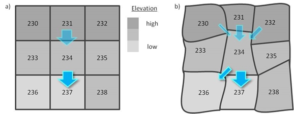
Fig. 4.1 Example grid connections showing water flow between grids.
Note
Arrows indicate the water flow in to and out of grid 234, but note that only only water flowing out of each grid is entered in SUEWS_SiteSelect.txt
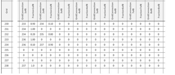
Fig. 4.2 Example values for the grid connections part of SUEWS_SiteSelect.txt for the grids.
An example SUEWS_SiteSelect.txt can be found below:
1    2    3        4      5       6       7        8           9       10      11     12     13     14       15       16       17       18       19       20       21          22          23          24      25      26      27     28     29        30        31        32         33           34             35             36         37         38         39         40         41         42         43         44         45           46          47           48         49       50       51                 52                 53                54             55                 56                 57                 58                 59         60            61           62                 63           64                 65           66                 67           68                 69           70                 71           72                 73           74                 75           76                 77           78                  79                  80                  81                  82                  83                       84                  85        86                  87                  88                  89                    90                    91                    92                  93                  94                  95                  96                  97                    98                    99                    100                   101
Grid Year StartDLS EndDLS lat     lng     Timezone SurfaceArea Alt     z       id     ih     imin   Fr_Paved Fr_Bldgs Fr_EveTr Fr_DecTr Fr_Grass Fr_Bsoil Fr_Water IrrFr_EveTr IrrFr_DecTr IrrFr_Grass H_Bldgs H_EveTr H_DecTr z0     zd     FAI_Bldgs FAI_EveTr FAI_DecTr PopDensDay PopDensNight TrafficRate_WD TrafficRate_WE QF0_BEU_WD QF0_BEU_WE Code_Paved Code_Bldgs Code_EveTr Code_DecTr Code_Grass Code_Bsoil Code_Water LUMPS_DrRate LUMPS_Cover LUMPS_MaxRes NARP_Trans CondCode SnowCode SnowClearingProfWD SnowClearingProfWE AnthropogenicCode IrrigationCode WaterUseProfManuWD WaterUseProfManuWE WaterUseProfAutoWD WaterUseProfAutoWE FlowChange RunoffToWater PipeCapacity GridConnection1of8 Fraction1of8 GridConnection2of8 Fraction2of8 GridConnection3of8 Fraction3of8 GridConnection4of8 Fraction4of8 GridConnection5of8 Fraction5of8 GridConnection6of8 Fraction6of8 GridConnection7of8 Fraction7of8 GridConnection8of8 Fraction8of8 WithinGridPavedCode WithinGridBldgsCode WithinGridEveTrCode WithinGridDecTrCode WithinGridGrassCode WithinGridUnmanBSoilCode WithinGridWaterCode AreaWall  Fr_ESTMClass_Paved1 Fr_ESTMClass_Paved2 Fr_ESTMClass_Paved3 Code_ESTMClass_Paved1 Code_ESTMClass_Paved2 Code_ESTMClass_Paved3 Fr_ESTMClass_Bldgs1 Fr_ESTMClass_Bldgs2 Fr_ESTMClass_Bldgs3 Fr_ESTMClass_Bldgs4 Fr_ESTMClass_Bldgs5 Code_ESTMClass_Bldgs1 Code_ESTMClass_Bldgs2 Code_ESTMClass_Bldgs3 Code_ESTMClass_Bldgs4 Code_ESTMClass_Bldgs5
1    2004 85       302    57.7700 11.8700 2.0000   1.0000      15.0000 10.0000 1.0000 0.0000 0.0000 1.0000   0.0000   0.0000   0.0000   0.0000   0.0000   0.0000   0.0000      0.0000      0.0000      0.0010  0.0000  0.0000  0.0100 0.2000 0.0000    0.0000    0.0000    0.0000     0.0000       0.0134         0.0095         0.7442     0.7955     661.0000   662.0000   661.0000   662.0000   663.0000   663.0000   661.0000   0.2500       1.0000      10.0000      1.0000     200.0000 660.0000 660.0000           660.0000           661.0000          660.0000       660.0000           660.0000           660.0000           660.0000           0.0000     0.1000        100.0000     0.0000             0.0000       0.0000             0.0000       0.0000             0.0000       0.0000             0.0000       0.0000             0.0000       0.0000             0.0000       0.0000             0.0000       0.0000             0.0000       661.0000            662.0000            663.0000            664.0000            665.0000            666.0000                 667.0000            -999.0000 0.0000              1.0000              0.0000              99999.0000            807.0000              99999.0000            1.0000              0.0000              0.0000              0.0000              0.0000              801.0000              99999.0000            99999.0000            99999.0000            99999.0000
1    2005 85       302    57.7700 11.8700 2.0000   1.0000      15.0000 10.0000 1.0000 0.0000 0.0000 1.0000   0.0000   0.0000   0.0000   0.0000   0.0000   0.0000   0.0000      0.0000      0.0000      0.0010  0.0000  0.0000  0.0100 0.2000 0.0000    0.0000    0.0000    0.0000     0.0000       0.0134         0.0095         0.7442     0.7955     661.0000   662.0000   661.0000   662.0000   663.0000   663.0000   661.0000   0.2500       1.0000      10.0000      1.0000     200.0000 660.0000 660.0000           660.0000           661.0000          660.0000       660.0000           660.0000           660.0000           660.0000           0.0000     0.1000        100.0000     0.0000             0.0000       0.0000             0.0000       0.0000             0.0000       0.0000             0.0000       0.0000             0.0000       0.0000             0.0000       0.0000             0.0000       0.0000             0.0000       661.0000            662.0000            663.0000            664.0000            665.0000            666.0000                 667.0000            -999.0000 0.0000              1.0000              0.0000              99999.0000            807.0000              99999.0000            1.0000              0.0000              0.0000              0.0000              0.0000              801.0000              99999.0000            99999.0000            99999.0000            99999.0000
-9
-9